Natural conditions
1. Geographic location and topographical conditions:
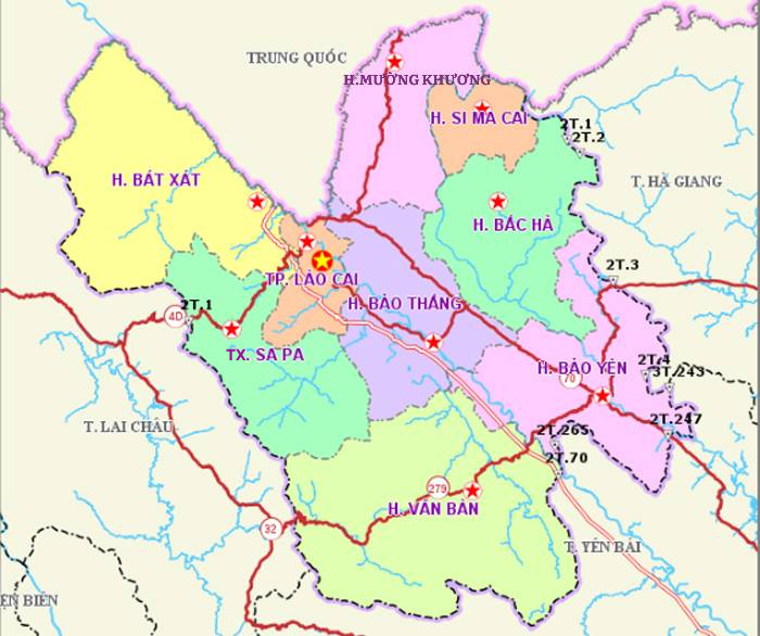
Lao Cai is a mountainous province in the Northwest of Vietnam with a natural area of 6,364.03 km2. The East borders Ha Giang province, the South borders Yen Bai province, the West borders Lai Chau province, the North borders Yunnan province - China with 182,086 km borderline.
The terrain of Lao Cai consists of many hills and valleys with deep division, cross-section, and steep slope. The two main mountain ranges are the Hoang Lien Son mountain range and the Con Voi mountain range with the Northwest - Southeast direction. Due to the divided topography, the division into low and high border is quite clear, in which the height from 300m - 1,000m occupies the majority of the province. Lao Cai is a province with many high peaks such as: Phu Ta Leng - 3096m, Lang Lung - 2913m, Ta Giang Phin - 2850m, especially Phan Xi Pang is the highest peak in the country 3143m.
2. Land:
Land resources in Lao Cai province are abundant and diverse, with a natural land area of 636,403 ha. The soil is divided into 10 main soil groups: humus in the mountains, humus - red gold in the mountains, yellow red soil, yellow red soil changed by growing rice, black soil, infertile soil, valley soil due to slope products. capacitor, alluvial soil, muddy soil ... suitable for many different types of plants.
3. Water:
The water resources of Lao Cai are mainly concentrated in a number of large rivers: the Red River (the length is 120 km), the Chay River (the length is 124 km), the Ngoi Nhu (the length is 68 km). The underground water resources of Lao Cai are plentiful, mostly exist in the form of underground water with reserves of about 30 million m3 (of which dynamic reserves are 4,448 million m3).
4. Climate:
Because of the differentiation of terrain elevation, the climate of Lao Cai is classified into 7 types and 12 kinds of climate, divided into 10 types of climate and 43 microclimates. There are 3 basic climate belts and 2 relatively distinct seasons: Tropical climate belt (<700 m, 20 -22 degree C), subtropical climate belt (700 m -1,800 m, 18 -20 degrees C), temperate climates (> 1,800 m, below 15 degrees C, in winter can drop below 0 degrees C and have icy, snow, rainy). The rainy season starts from April to October, the dry season starts from October to March next year.
5. Forest:
In particular, 140,512 ha of natural forest, including 60,928 ha of business forest, 79,584 ha of protection forest with 803 ha of rich forest with a total timber reserve of 160.75 m3 / ha; 10,982 ha of average forest have a wood reserve of 139,54 m3 / ha.
Hoang Lien National Park (Sa Pa) with very rich natural ecosystems: there are 2,024 plant species belonging to 200 families, including 66 species in the Red Book of Vietnam, 32 rare and 11 species at risk extinction such as cypress, pine needles, bamboo pine, red pine, pine needles, pine cones, etc; 66 species of mammals, including 16 species listed in the Vietnam Red List of birds, mammals, reptiles, many species. particularly rare and valuable fauna and flora, with a treasure of precious and rare plant gene funds accounting for 50% of Vietnam's rare and precious plant species.
6. Minerals:
Minerals are a prominent resource and economic strength of Lao Cai province. The research and finding works have discovered 103 points, 27 sediment dispersion rings and many radioactive anomalies. Minerals are diverse in types, including metallic, non-metallic and fuel minerals with 31 different types, most notably copper, iron and apatite.